Thursday, December 6, 2012

Final Blog Post~ The future of Naica Mines and it's surrounding geography~


Satellite image of the state of Chihuahua shows the varying terrain from the green alpine mountains in the southwest, to the steppe highlands in the center, to the desert in the east.


     The region of Chihuahua, Mexico has a diverse geography. Known for it's desert for namesake, it has more forests than any other Mexiacan state. The southern point of the Rock Mountains reach this region as well, making it a mineral rich area for mining. Subtropical lowlands and highlands exist to the south west. It has a varied flora and fauna due to this unique geography as well. The cave's of Naica mines are still somewhat of an enigma but are certainly attributed to the coastal waters and weather patterns it has been effected to for many years. In this posting I will describe and discuss what I think this region will become 1,000, 10,000 and 1,000,000 years into the future.

  •      1,000 years from today ~                                                                                                                         I surmise that by 3012 this region will have gone through a mild change in terrain. The forest will have dried up and fire will have engulfed half of it's trees. A cualdren of pressurized, molten rock that the cave borders is jarred loose creating thermal expansion and a pocket of the cave to be filled in and cooled. The gypsum crystalization is halted throughout the rest of the cave as the unique water chemistry is no longer present. The limestone rock still expands and contracts with the heating and cooling prosesses. Weathering of some of the shallower caves are effected by new root growth of the newer trees above. Creating some cracking and evaporation of some humidity and moisture.  


  •      10,000 years from today ~                                                                                                                There is a meteor that hits the Earth in the south pacific. Creating a world wide catastrophy. Massive tsunamis and earthquakes occur on numerous continents. Mexico gets 40 foot surges that pummel the shoreline wiping out all surrounding coastlines. 50 years afterwards the Conchos River, the largest river in Chihuahua, begins to form again after being flooded completely. We find numerous different channels that become braided and meandering back to the shore. The flow has changed from what it was in the past due to the devestated terrain form the mass flooding. The cave is virtually buried at this point from sediment and volcanic activity.


       It's hard to extrapolate completely on how the earth will change over the next 1,000,000 years. There are so many variables that must be taken into consideredation. Weathering, erosion, volcanic activity, flooding, cracking, drying and moisturizing are all factors to consider outside of the devestational. The Earth is brilliant organism that is resiliant and every changing. Looking at it from an objective and outside view puts things into perspective. Knowing it's past really helps us to gauge  it's future.

  •     1,000,000 years from today ~                                                                                                           After 1 million years passes we find the Earth in a very differnt condition. A global warming has occured over the last 50,000 years. Water levels rise to 150 feet above the formal sea level. Many low lying continents have been fully submerged. But, since a pole shift has occured, the Earth has lost most of it's atmosphere and a drastic mass cooling of the planet is in place. The next ice age is beginning. The land mass known as Mexico is now in the Northern hemisphere. Under 1,000 feet of ice.                    


Tuesday, November 13, 2012

Soil and Climate


Many of the caves in the Yucatan peninsula are found in the calcareous sub-soil. This type of soil has a very high pH and is very alkaline as well. This is mainly die to the weak acidity in carbonic acid.  Related with climate, a record of multi-technique fluid inclusion data and pollen spectra from cave and mine gypsum indicates surprisingly that climatic changes occurring at Naica could have controlled fluid composition in these caves, and hence crystal growth. Like much of the Carribean,the peninsula lies within the Atlantic Hurricane Belt, and with it's almost uniformly flat terrain it is vulnerable to these large storms coming from the east. The 2005 Hurricane season was extremely destructive to this region. Hurricane Wilma and Hurricane Emily were class 5 storms that were quite damaging. How this effects the caves is unknown, due to their relative depth from the surface. This region has heavy rainfall mainly form April to October. Breezes have a cooling effect, and humidity is generally  high. "Microthermometry and LA-ICP-Mass Spectrometry of fluid inclusions indicate that the shallow, chemically peculiar, saline fluid (up to 7.7 eq. wt.%NaCl) of CLE could have formed from evaporation, during a dry and hot climatic period. The fluid of the deep caves was instead of low salinity (∼ 3.5 eq. wt.% NaCl) and chemically homogeneous, and was poorly affected by evaporation".(*) It is thought that the that the combining of these two fluids maintained at a stable condition allowed for the massive gypsum crystals to form. This seems to have taken place during cycles of warm-dry and fresh-wet climatic periods, which is typical weather for the region. Pollen grains were taken from a 35 ka-old gypsum crystal and it corresponds to the data that it was these soisl and water that came from a mixed broadleaf wet forest. This suggests precipitation during a fresh-wet climatic period and shows how this process can occur over time.

http://www.sciencedirect.com/science/article/pii/S0012821X09007195 (*)
http://archive.lib.msu.edu/tic/gcman/article/1990jun60.pdf
http://www.geochemicaltransactions.com/content/7/1/6

Thursday, October 11, 2012

The Hydrological Process...

~CAVE FORMATION ~

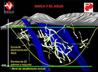
    The Naica caves had quite a unique and rare process in how they formed. It is a known as a thermal aquifer.  An aquifer is a body of saturated rock through which water can easily move. Aquifers must be both permeable and porous and include such rock types as sandstone, conglomerate, fractured limestone and unconsolidated sand and gravel. Fractured volcanic rocks known as columnar basalts also make good aquifers. The rubble zones between volcanic flows are generally both porous and permeable and make excellent aquifers. In order for a well to be productive, it must be drilled into an aquifer. Rocks such as granite and schist are generally poor aquifers because they have a very low porosity. However, if these rocks are highly fractured, they make good aquifers. A well is a hole drilled into the ground to penetrate an aquifer. Normally such water must be pumped to the surface. If water is pumped from a well faster than it is replenished, the water table is lowered and the well may go dry. When water is pumped from a well, the water table is generally lowered into a cone of depression at the well. Groundwater normally flows down the slope of the water table towards the well.
     Every aquifer is unique. Volcanic thermal activity heats the water to extremely hot temperatures. The boundaries of an aquifer are usually gradational (taking place by different degrees) into other aquifers, so that an aquifer can be part of an aquifer system. The top of an unconfined aquifer is what is known as the water table. A confined aquifer has at least one aquitard at its top and, if it is stacked with others, an aquitard at its base. Continental cooling and thermal expansion make this possible.
Click for larger view.
figure 1. Click on image for larger view.

      There is still quite a lot to be explored on the different formations of these magnificant crystals. I will be exploring in this blog further along how the geography of this region has played a role on these caves.


http://www.telegraph.co.uk/travel/picturegalleries/8660364/Amazing-caves-of-giant-crystals-inside-the-Naica-Mine-in-Chihuahua-Mexico.html

http://www.rtbot.net/crystal_caverns

http://geology.geoscienceworld.org/content/35/4/327.abstract

Thursday, September 20, 2012

Cave Formations

    These magnificiant caves were discovered on accident by miners draining the mones to extract minerals. The process revealed a natural phenomenon unknown to mankind. The formation of macro crystals is related to the relatively unknown geological conditions existing in the mine. They were formed under water in an area where sulphide saturated phreatic thermal waters (52 degrees C) came in contact with oxygen-rich cold waters that have naturally infiltrated from the outside. Essentially, these two waters could not mix thus creating the gigantic crystal gypsum deposits that we see today. It took thousands and thousands of years for this process to occur.
 
                                   
                                    http://www.naica.com.mx/english/internas/interna2_1.htm


       The sedimentary rock known as Limestone, which is mainly composed of calcium carbonate in the form of the mineral calcite. The Naica mines are comprised mostly Limestone that is formed from and near shallow, warm bodies of water where biological debris such as organism waste, shells, and fossils. Most of the Limestone-forming environments are found between 30 degrees north latitude and 30 degrees south latitude. Making the Gulf of Mexico prime real estate for these wonderous caves. Evaporation processes are also a contributing factors by in where droplets of water drain through the cracks and fissures in the surface creating the stalactites.

      The mine of Naica is in a semi desertic region about 100 kilometers southeast of the city of Chihuahua. The area is crossed by a series of low ridges. The mine opens on the northern side of one such ridge, the Sierra de Naica. It is an anticline, outcropping from a wide alluvial plain, and composed of carbonate forma- tions 12 kilometers long and 7 kilometers wide. Intrusive magmatic activity, which affected this part of the North American subcontinent, occurred between 25 and 26 million years ago. Recent coring, by the mine owner revealed an igneous body about 1,140 meters deep. The whole mining area sits on top of this magma body that heats the groundwater: water flowing into the mining galleries has a temperature close to 127 degrees. There is little risk of eruption from the chambers.


SOURCES: http://www.slideshare.net/random13579/naica-crystal-cave
                  http://news.nationalgeographic.com/news/2007/04/photogalleries/giant-crystals-cave/
                  http://www.stormchaser.ca/caves/naica/naica.html


Thursday, August 23, 2012

My name is Ezra-David Darnell. I'm creating this blog out of my wild infatuation of one of the worlds most fascinating natural marvals... the crystal cave of Naica, Mexico. 980 feet below the arid desert surface of the Chihuahan desert exists a wonder of natural creation.  Monolithic selenite crystals (mainly gypsum) cris-cross and protrude the cavern walls. The cave is extreme in other ways as well. It reaches a temperature of upwards of 136 degrees Farenheit. Due to this, the crystal cave is reletively and to some, frustratingly unexplored. Without proper protection humans can only endure approximately 10 minutes of the intense exposure at one time.
 I selected this specific location and topic because I am very musch intrigued in the unknown as well as about crystal formations and their relevance to ancient civilizations and certain 'alternative archeological' views of what their powers might posses, whether healing or technological. Researching how they were formed in such a dry and hot geological lanscape in very interesting to me as wll. I'm very excited to research these caves and explore my mind of their significance to our beautiful and magestic planet.